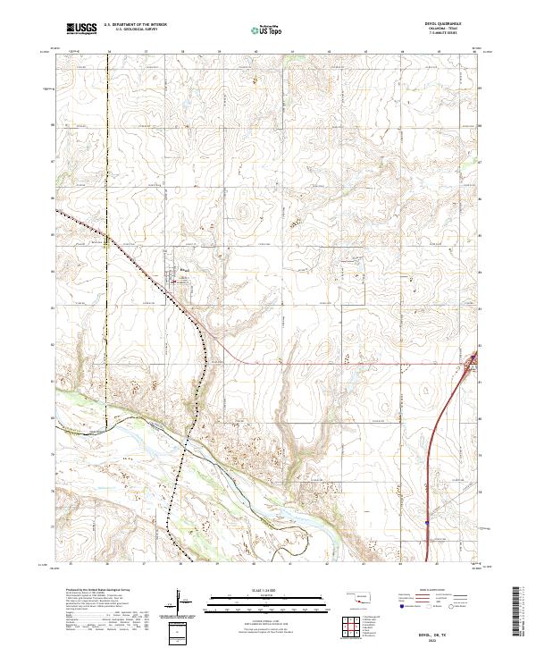
2022 Map of Devol
USGS Topo · Published 2022About this map
Devol sits in the southwest corner of Cotton Co, serving as a central hub for the surrounding agricultural landscape of southern Oklahoma. The town's grid is anchored by residential and service streets like Mulberry ST and Enid Ave, including a local Po and the nearby Devol Cem. The southern edge of the quadrangle is defined by the shifting course of the Red River, which forms the natural boundary between Oklahoma and Texas. Within the river's channel, Goat Island sits caught between the main current and smaller braids like Bule Cr. North of the river, a dense network of section-line roads such as Co RD e1940 and Co RD n2480 organizes the terrain, while seasonal drainages like Wildhorse Cr wind through the open countryside.
Find a feature on this map
49 named features on this map. Tap any name to fly to it.
Don’t see what you’re looking for? This feature index may not catch every label — zoom into the map to look around manually.
Map Details
Editions of this 2022 Devol Map
This is the sole edition of this map. No revisions or reprints were ever made.
Other maps of this area

1915 · Clara
USGS Topo · 1:24,000

1915 · Burkburnett
USGS Topo · 1:24,000

1918 · Buckburnett
USGS Topo · 1:31,680

1918 · Clara
USGS Topo · 1:31,680

1955 · Lawton
USGS Topo · 1:250,000

1957 · Burkburnett
USGS Topo · 1:62,500

1957 · Randlett
USGS Topo · 1:62,500

1962 · Chattanooga
USGS Topo · 1:62,500

1962 · Walters
USGS Topo · 1:62,500
1972 · Clara
USGS Topo · 1:24,000