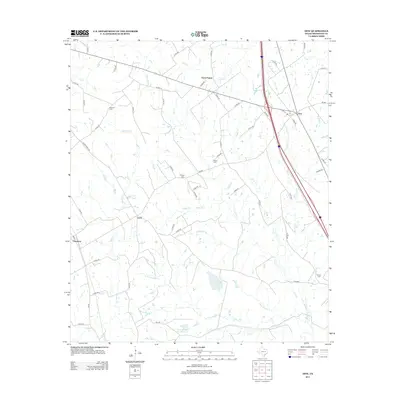
2013 Map of Dew
USGS Topo · Published 2013About this map
Avant Prairie and the community of Dew anchor this section of east-central Texas, where the landscape is defined by an intricate network of creeks and branches. The area’s genealogical record is preserved in several rural burial grounds, including Kendrick Cem, Salem Cem, and Philpott Cem, which are scattered among the ranch lands. Small settlements like Luna and Freestone appear along the local road system, connected by a web of county roads that cross numerous watercourses such as Graveyard Br and Upper Keechi Cr. The southern portion of the quadrangle shows significant water management features like Hunt Ranch Lake Number 1 and Hunt Ranch Lake Number 2, illustrating the importance of livestock and ranching in this portion of Freestone County during the early 21st century.
Find a feature on this map
72 named features on this map. Tap any name to fly to it.
Don’t see what you’re looking for? This feature index may not catch every label — zoom into the map to look around manually.
Map Details
Editions of this 2013 Dew Map
This is the sole edition of this map. No revisions or reprints were ever made.
Other maps of this area

1919 · Fairfield
USGS Topo · 1:62,500

1920 · Mexia
USGS Topo · 1:62,500

1954 · Waco
USGS Topo · 1:250,000

1955 · Waco
USGS Topo · 1:250,000

1956 · Jewett
USGS Topo · 1:62,500

1963 · Teague North
USGS Topo · 1:24,000

1965 · Dew
USGS Topo · 1:24,000
1965 · Lanely
USGS Topo · 1:24,000
1965 · Buffalo
USGS Topo · 1:24,000
1965 · Fairfield
USGS Topo · 1:24,000