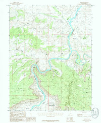
1985 Map of Dewey
USGS Topo · Published 1986About this map
The Colorado River and Dolores River converge in this high-desert landscape, creating a complex network of river bottoms and steep canyon walls. Small settlements like Dewey and Richardson are situated near these vital water sources, with Dewey notably featuring a Gaging Station to monitor the river's flow. The terrain is characterized by massive formations such as the Dome Plateau and Hotel Mesa, while landmarks like the Natural Arch and the Richardson Amphitheater highlight the area's geological diversity. The map reveals how early 1980s navigation and settlement were dictated by the deep incisions of Bull Canyon and Yellow Jacket Canyon, forcing transit through specific breaks like Professor Valley and across several named bottoms, including Ninemile Bottom and Hittle Bottom.
Find a feature on this map
32 named features on this map. Tap any name to fly to it.
Don’t see what you’re looking for? This feature index may not catch every label — zoom into the map to look around manually.
Map Details
Editions of this 1985 Dewey Map
2 editions found
Other maps of this area

1885 · La Sal
USGS Topo · 1:250,000

1954 · Mt. Waas 4 NW
USGS Topo · 1:24,000

1954 · Mt. Waas 3 NE
USGS Topo · 1:24,000

1954 · Mt. Waas 1 SW
USGS Topo · 1:24,000

1954 · Mt. Waas 3 NW
USGS Topo · 1:24,000

1954 · Mt. Waas 1 NW
USGS Topo · 1:24,000

1954 · Coates Creek
USGS Topo · 1:62,500

1954 · Polar Mesa
USGS Topo · 1:62,500

1954 · Castle Valley
USGS Topo · 1:62,500

1955 · Mt. Waas 2 SE
USGS Topo · 1:24,000