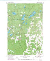
1955 Map of Dewey Lake
USGS Topo · Published 1971About this map
The Chisholm northern periphery and the surrounding Iron Range wilderness are captured here during a period of transition, following the 1947 aerial surveys and 1969 field revisions. The landscape is defined by its glacial hydrology, featuring a dense network of water bodies including the central Dewey Lake, the elongated Long Lake, and Island Lake. These waters are connected by the Shannon River as it winds south toward the edge of town.
Find a feature on this map
26 named features on this map. Tap any name to fly to it.
Don’t see what you’re looking for? This feature index may not catch every label — zoom into the map to look around manually.
Map Details
Editions of this 1955 Dewey Lake Map
4 editions found
Other maps of this area

1951 · Hibbing
USGS Topo · 1:24,000

1951 · Buhl
USGS Topo · 1:24,000

1952 · Keewatin
USGS Topo · 1:24,000

1954 · Hibbing
USGS Topo · 1:250,000

1955 · Dark Lake
USGS Topo · 1:24,000

1955 · Dewey Lake SE
USGS Topo · 1:24,000

1955 · Dewey Lake NW
USGS Topo · 1:24,000

1955 · Dewey Lake
USGS Topo · 1:24,000

1957 · Hibbing
USGS Topo · 1:250,000

1957 · Hibbing
USGS Topo · 1:24,000