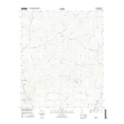
2014 Map of Dexter
USGS Topo · Published 2014About this map
Sofkahatchee Cr and its numerous tributaries, including Fisher Cr and John Bear Cr, carve through this section of Elmore County, defining a landscape dominated by creek drainage and small impoundments like Milam Lake. Small crossroads settlements and residential clusters such as Dexter, Greer, and Santuck are connected by a network of winding local roads, including Weoka Rd and Grier Rd. The area maintains a rural character with several family and community landmarks, notably Pleasant Ridge Cem and Little Flock Cem. US Highway 231 serves as the primary corridor in the western portion of the map, passing by Riddle and the newer developments of Ten Cedars Estates. This survey illustrates the persistent rural settlement patterns in central Alabama where small creeks like Yellow Water Cr and Little Weoka Cr continue to influence the local geography.
Find a feature on this map
85 named features on this map. Tap any name to fly to it.
Don’t see what you’re looking for? This feature index may not catch every label — zoom into the map to look around manually.
Map Details
Editions of this 2014 Dexter Map
This is the sole edition of this map. No revisions or reprints were ever made.
Other maps of this area

1901 · Wetumpka
USGS Topo · 1:125,000

1901 · Wetumpka
USGS Topo · 1:62,500

1903 · Wetumpka
USGS Topo · 1:125,000

1953 · Montgomery
USGS Topo · 1:250,000

1956 · Montgomery
USGS Topo · 1:250,000

1957 · Montgomery
USGS Topo · 1:250,000
1959 · Wetumpka
USGS Topo · 1:62,500

1959 · Elmore
USGS Topo · 1:62,500

1971 · Richville
USGS Topo · 1:24,000
1971 · Equality
USGS Topo · 1:24,000