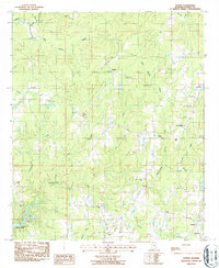
1987 Map of Dexter
USGS Topo · Published 1987About this map
Jordan Lake and the winding course of Sofkahatchee Creek dominate this central Alabama landscape, where rural communities like Dexter and Weoka were established amidst a network of small family-named waterways. This late-1980s data shows a region defined by its spiritual and social centers, with numerous country churches such as Bethlehem Ch, Trinity Ch, and the Balm of Gilead Ch serving the local population. The map provides a detailed view of the terrain before significant modern expansion, capturing family cemeteries like Mahn Cem and Pleasant Ridge Cem that offer vital clues for genealogical research. Connectivity in this river-rich area is noted through landmarks like Swayback Bridge and Collier Bridge, while Evans Landing Field represents the small-scale aviation infrastructure of the era. The land transitions from the high ground near Santuck down to the low-lying Flat terrain, illustrating the varied geography of Elmore County.
Find a feature on this map
30 named features on this map. Tap any name to fly to it.
Don’t see what you’re looking for? This feature index may not catch every label — zoom into the map to look around manually.
Map Details
Editions of this 1987 Dexter Map
This is the sole edition of this map. No revisions or reprints were ever made.
Other maps of this area

1901 · Wetumpka
USGS Topo · 1:125,000

1901 · Wetumpka
USGS Topo · 1:62,500

1903 · Wetumpka
USGS Topo · 1:125,000

1953 · Montgomery
USGS Topo · 1:250,000

1956 · Montgomery
USGS Topo · 1:250,000

1957 · Montgomery
USGS Topo · 1:250,000
1959 · Wetumpka
USGS Topo · 1:62,500

1959 · Elmore
USGS Topo · 1:62,500

1971 · Richville
USGS Topo · 1:24,000
1971 · Equality
USGS Topo · 1:24,000