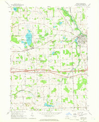
1964 Map of Dexter
USGS Topo · Published 1966About this map
The Huron River carves through the northeastern corner of this Washtenaw County landscape, anchoring the village of Dexter and the preserved lands of Hudson Mills Metropolitan Park. To the west, the Chelsea State Game Area surrounds the wetlands of Fourmile Lake, illustrating the regional transition from recreational wilderness to active agriculture. The New York Central railroad corridor serves as a primary east-west artery, passing through the small settlements of Lima Center and Jerusalem. Local history is visible in the distribution of rural landmarks, including the Salem Sch and several family-named burial grounds such as Parker Cem and Lima Cem. The map captures a mid-1960s snapshot of a township economy still heavily influenced by small-scale resource extraction, evidenced by numerous Gravel Pits and a Marl Pit scattered across the glacial terrain near Prospect Hill.
Find a feature on this map
51 named features on this map. Tap any name to fly to it.
Don’t see what you’re looking for? This feature index may not catch every label — zoom into the map to look around manually.
Map Details
Editions of this 1964 Dexter Map
4 editions found
Other maps of this area

1902 · Dexter
USGS Topo · 1:62,500

1904 · Ann Arbor
USGS Topo · 1:125,000

1906 · Dexter
USGS Topo · 1:62,500

1906 · Saline
USGS Topo · 1:62,500

1908 · Ann Arbor
USGS Topo · 1:125,000

1919 · Stockbridge
USGS Topo · 1:62,500

1922 · Stockbridge
USGS Topo · 1:62,500

1942 · Stockbridge
USGS Topo · 1:62,500

1948 · Manchester
USGS Topo · 1:62,500

1949 · Manchester
USGS Topo · 1:62,500