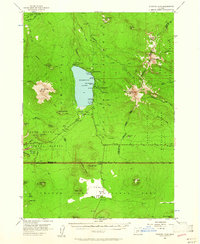
1956 Map of Diamond Lake
USGS Topo · Published 1961About this map
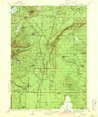
Diamond Lake serves as the central hub of this mid-century Cascades landscape, surrounded by a concentration of early forest service and recreational infrastructure. The presence of the Diamond Lake Guard Sta, a State Fish Hatchery, and several established sites like White Fir Forest Camp indicate a transition toward managed natural resources and seasonal tourism. High alpine peaks including Mt Thielsen and Mt Bailey define the skyline, while the southern portion of the map reveals the stark topography of the Pumice Desert within Crater Lake National Park. The map documents a complex boundary system where the Douglas and Klamath county lines intersect with four distinct national forest and park jurisdictions. For researchers, the detailed naming of small watercourses like Thielsen Creek and Silent Creek provides a clear view of the headwaters for the Clearwater River and Rogue River.
Find a feature on this map
71 named features on this map. Tap any name to fly to it.
Don’t see what you’re looking for? This feature index may not catch every label — zoom into the map to look around manually.
Map Details
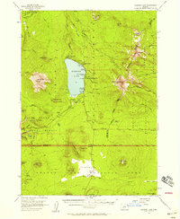
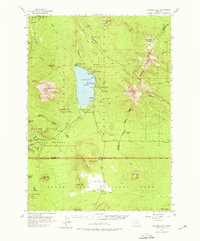
Editions of this 1956 Diamond Lake Map
3 editions found
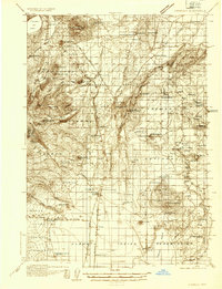
Other maps of this area

1889 · Klamath
USGS Topo · 1:250,000

1891 · Ashland
USGS Topo · 1:250,000

1893 · Ashland
USGS Topo · 1:250,000

1894 · Klamath
USGS Topo · 1:250,000

1897 · Ashland
USGS Topo · 1:250,000

1917 · Diamond Lake
USGS Topo · 1:125,000
1935 · Chemult
USGS Topo · 1:96,000
1941 · Chemult
USGS Topo · 1:125,000

1955 · Crescent
USGS Topo · 1:250,000

1955 · Klamath Falls
USGS Topo · 1:250,000