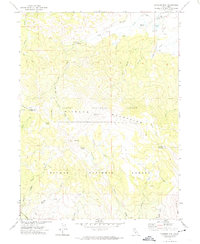
1972 Map of Diamond Mtn
USGS Topo · Published 1972About this map
The high ridge of the Diamond Mountains serves as a geographic and administrative spine for this 1972 survey, marking the boundary between the Lassen National Forest and the Plumas National Forest. The landscape is defined by its transition from the steep elevations of Diamond Mtn and the Gilman Basin to the high-country flats of Aspen Flat. Evidence of localized infrastructure is found in the scattered water management features such as Nagel Reservoir, Ridenoure Reservoir, and the networks of Ditch lines feeding into the lower meadows.
Find a feature on this map
44 named features on this map. Tap any name to fly to it.
Don’t see what you’re looking for? This feature index may not catch every label — zoom into the map to look around manually.
Map Details
Editions of this 1972 Diamond Mtn Map
3 editions found
Other maps of this area

1886 · Honey Lake
USGS Topo · 1:250,000

1891 · Honey Lake
USGS Topo · 1:250,000

1893 · Honey Lake
USGS Topo · 1:250,000

1950 · Kettle Rock
USGS Topo · 1:62,500

1950 · Greenville
USGS Topo · 1:62,500

1954 · Susanville
USGS Topo · 1:62,500

1955 · Westwood
USGS Topo · 1:62,500

1955 · Westwood
USGS Topo · 1:250,000

1958 · Westwood
USGS Topo · 1:250,000

1959 · Westwood
USGS Topo · 1:250,000