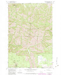
1967 Map of Diamond Peak
USGS Topo · Published 1983About this map
Umatilla National Forest occupies the heart of this high-elevation landscape, where the Blue Mountains transition into the deep drainages of the Grande Ronde river system. By the late 1960s, this area remained largely defined by its primitive infrastructure and seasonal camps, including Kelly Camp and the First Creek Cabin. The topography is a complex network of steep ridges and high plateaus, most notably the wide expanses of Grouse Flat and Moore Flat.
Find a feature on this map
42 named features on this map. Tap any name to fly to it.
Don’t see what you’re looking for? This feature index may not catch every label — zoom into the map to look around manually.
Map Details
Editions of this 1967 Diamond Peak Map
3 editions found
Other maps of this area

1937 · Pomeroy
USGS Topo · 1:96,000

1942 · Pomeroy
USGS Topo · 1:125,000

1943 · Saddle Butte
USGS Topo · 1:62,500

1946 · Saddle Butte
USGS Topo · 1:62,500

1955 · Pullman
USGS Topo · 1:250,000

1955 · Grangeville
USGS Topo · 1:250,000

1958 · Pullman
USGS Topo · 1:250,000

1959 · Grangeville
USGS Topo · 1:250,000

1967 · Troy
USGS Topo · 1:24,000

1967 · Eden
USGS Topo · 1:24,000