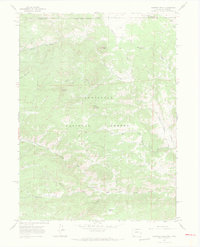
1967 Map of Diamond Peak
USGS Topo · Published 1971About this map
Roosevelt National Forest straddles the high-country border between Colorado and Wyoming, dominated by the prominent granite heights of Diamond Peak and Deadhouse Mountain. The landscape is a network of water drainage and timbered ridges, where the North Fork Cache la Poudre River cuts through the southern reaches near Chicken Park. Isolated prospects on the northern slopes of the forest suggest the early search for minerals in this complex terrain. The map records a transition from the rugged canyons of Devils Canyon to more accessible areas served by the Cherokee Park Road, showing the evolution of mountain transit through these national lands during the late 1960s. High-altitude landmarks like Bald Mtn and Green Mountain provide fixed points for navigating the backcountry near the state line.
Find a feature on this map
24 named features on this map. Tap any name to fly to it.
Don’t see what you’re looking for? This feature index may not catch every label — zoom into the map to look around manually.
Map Details
Editions of this 1967 Diamond Peak Map
3 editions found
Other maps of this area

1895 · Laramie
USGS Topo · 1:125,000

1902 · Laramie
USGS Topo · 1:125,000

1905 · Sherman
USGS Topo · 1:125,000

1905 · Laramie
USGS Topo · 1:125,000

1906 · Laramie
USGS Topo · 1:125,000

1907 · Livermore
USGS Topo · 1:125,000

1908 · Laramie
USGS Topo · 1:125,000

1909 · Livermore
USGS Topo · 1:125,000

1916 · Home
USGS Topo · 1:125,000

1920 · Home
USGS Topo · 1:125,000