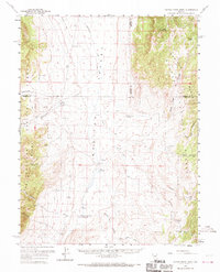
1960 Map of Dianas Punch Bowl
USGS Topo · Published 1970About this map
Dianas Punch Bowl (Hot Springs) serves as the geographic and hydrologic centerpiece of this landscape, marking a notable geothermal feature within the high-desert valley. Located in central Nevada, the area is defined by the broad expanse of Monitor Valley, flanked by the high elevations of the Monitor Range to the west and the Toiyabe Range to the east. The 1960s-era settlement pattern is sparse, comprised primarily of established cattle operations and family landmarks such as Potts Ranch, Monitor Ranch, and The Homestead. These outposts are connected by a network of drainage systems like Stoneberger Creek and numerous water sources including White Sage Spring and Johnny Potts Spring. A single Airstrip and a network of Jeep Trails provide the primary means of traversing this high-elevation ranching country within the Toiyabe National Forest.
Find a feature on this map
39 named features on this map. Tap any name to fly to it.
Don’t see what you’re looking for? This feature index may not catch every label — zoom into the map to look around manually.
Map Details
Editions of this 1960 Dianas Punch Bowl Map
3 editions found

Other maps of this area

1926 · Roberts Mountains
USGS Topo · 1:250,000

1929 · Roberts Mountains
USGS Topo · 1:250,000

1955 · Millett
USGS Topo · 1:250,000

1956 · Horse Heaven Mtn
USGS Topo · 1:62,500

1956 · Antelope Peak
USGS Topo · 1:62,500

1956 · Tonopah
USGS Topo · 1:250,000

1959 · Tonopah
USGS Topo · 1:250,000

1959 · Millett
USGS Topo · 1:250,000

1960 · Hickison Summit
USGS Topo · 1:62,500

1960 · Spencer Hot Springs
USGS Topo · 1:62,500