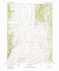
1960 Map of Dianas Punch Bowl
USGS Topo · Published 1985About this map
Monitor Valley serves as the central corridor of this 1960 survey, a high-desert landscape defined by isolated ranching outposts and geothermal activity. The most striking geological feature is Dianas Punch Bowl, a deep natural cauldron in the valley floor. The map records the human footprint on this remote terrain through several named properties, including the Potts Ranch, Monitor Ranch, and The Homestead, which are connected by a network of unimproved roads and a jeep trail. Water sources are vital landmarks here, ranging from the flowing Stoneberger Creek to named seeps and springs like Johnny Potts Spring and White Sage Spring. This era captures the valley's mid-century character, where an airstrip near The Monitor suggests the logistical challenges of managing these expansive basin-and-range cattle operations.
Find a feature on this map
35 named features on this map. Tap any name to fly to it.
Don’t see what you’re looking for? This feature index may not catch every label — zoom into the map to look around manually.
Map Details
Editions of this 1960 Dianas Punch Bowl Map
3 editions found

Other maps of this area

1926 · Roberts Mountains
USGS Topo · 1:250,000

1929 · Roberts Mountains
USGS Topo · 1:250,000

1955 · Millett
USGS Topo · 1:250,000

1956 · Horse Heaven Mtn
USGS Topo · 1:62,500

1956 · Antelope Peak
USGS Topo · 1:62,500

1956 · Tonopah
USGS Topo · 1:250,000

1959 · Tonopah
USGS Topo · 1:250,000

1959 · Millett
USGS Topo · 1:250,000

1960 · Hickison Summit
USGS Topo · 1:62,500

1960 · Spencer Hot Springs
USGS Topo · 1:62,500