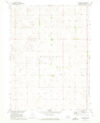
1970 Map of Dickens NE
USGS Topo · Published 1973About this map
The rolling Nebraska landscape of Lincoln County appears in this 1970 survey as a series of topographic depressions and scattered agricultural developments. This area, largely defined by the Sellers terrain, shows a sparse distribution of rural infrastructure typical of the high plains. Vital community nodes are clearly identified, including the Community Building and the rural Lone Star Sch, which served as the educational and social anchor for local families. The map also records the technical footprint of the era, noting a prominent Radio Tower and various Well sites across the sections. These features illustrate the intersection of local community life and the infrastructure necessary for land management and communication in a rural setting during the mid-20th century.
Find a feature on this map
6 named features on this map. Tap any name to fly to it.
Don’t see what you’re looking for? This feature index may not catch every label — zoom into the map to look around manually.
Map Details
Editions of this 1970 Dickens NE Map
This is the sole edition of this map. No revisions or reprints were ever made.
Other maps of this area

1899 · North Platte
USGS Topo · 1:125,000

1902 · North Platte
USGS Topo · 1:125,000

1954 · McCook
USGS Topo · 1:250,000

1954 · North Platte
USGS Topo · 1:250,000

1956 · North Platte
USGS Topo · 1:250,000

1956 · Wellfleet NW
USGS Topo · 1:24,000

1956 · Dickens
USGS Topo · 1:24,000

1956 · Somerset
USGS Topo · 1:24,000

1956 · Wellfleet
USGS Topo · 1:24,000

1957 · North Platte
USGS Topo · 1:250,000