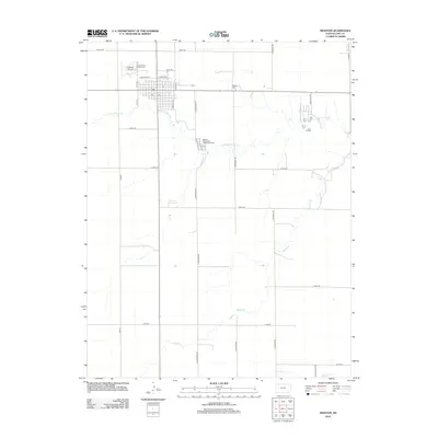
2012 Map of Dighton
USGS Topo · Published 2012About this map
Dighton serves as the central hub of this Lane County landscape, where a precise grid of residential streets meets the open agricultural plains of western Kansas. The town’s civic and social infrastructure is well-defined, including the Lane County Fairgrounds, the local Post Office, and the Dighton Airport on the northwestern edge. This 2012 survey illustrates a landscape managed by a network of county roads, such as Kaw Rd and S Ogallalah Rd, which partition the territory into large sections for dryland farming. The natural drainage of the region is traced by the winding paths of S Fork Walnut Cr and Buffalo Cr, which carve subtle topography through the otherwise level prairie. Outside the town center, the Dighton Cem and the Dighton Wastewater Treatment Facility mark the furthest reaches of the settlement's footprint before the transition to expansive rural acreage.
Find a feature on this map
31 named features on this map. Tap any name to fly to it.
Don’t see what you’re looking for? This feature index may not catch every label — zoom into the map to look around manually.
Map Details
Editions of this 2012 Dighton Map
This is the sole edition of this map. No revisions or reprints were ever made.
Other maps of this area

1955 · Scott City
USGS Topo · 1:250,000

1958 · Scott City
USGS Topo · 1:250,000

1974 · Dighton SW
USGS Topo · 1:24,000

1974 · Amy SE
USGS Topo · 1:24,000

1974 · Dighton
USGS Topo · 1:24,000

1974 · Alamota
USGS Topo · 1:24,000

1974 · Dighton SE
USGS Topo · 1:24,000

1974 · Amy
USGS Topo · 1:24,000

1974 · Healy
USGS Topo · 1:24,000

1974 · Shields SE
USGS Topo · 1:24,000