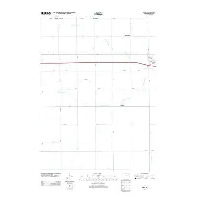
2013 Map of Dike
USGS Topo · Published 2013About this map
Dike serves as the primary hub in this portion of Grundy County, situated where the local road network converges near the Fox Ridge Golf Course. The landscape is defined by the agricultural grid of the Iowa interior, punctuated by smaller settlements such as Sinclair, Swanton, and Dairyville to the north, and Lincoln to the south. These communities are linked by a precise system of numbered streets and lettered avenues, including E Buttermaker and N Lincoln. The drainage of the region is shaped by the winding paths of the N Fork Black Hawk Cr and the S Fork Blackhawk Cr, which cut across the geometric property lines. This survey captures the rural character of the area in the early 21st century, showing the persistence of small unincorporated places and the vital watercourses like Willow Cr that have long influenced local land use and development patterns.
Find a feature on this map
32 named features on this map. Tap any name to fly to it.
Don’t see what you’re looking for? This feature index may not catch every label — zoom into the map to look around manually.
Map Details
Editions of this 2013 Dike Map
This is the sole edition of this map. No revisions or reprints were ever made.
Other maps of this area

1954 · Waterloo
USGS Topo · 1:250,000

1955 · Waterloo
USGS Topo · 1:250,000

1971 · Zaneta
USGS Topo · 1:24,000

1971 · Dike
USGS Topo · 1:24,000

1971 · Lincoln
USGS Topo · 1:24,000

1971 · Stout
USGS Topo · 1:24,000

1971 · Reinbeck
USGS Topo · 1:24,000
1971 · New Hartford
USGS Topo · 1:24,000

1979 · Grundy Center
USGS Topo · 1:24,000

1979 · Holland
USGS Topo · 1:24,000