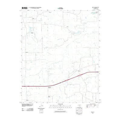
2010 Map of Dike
USGS Topo · Published 2010About this map
White Oak Creek and its many tributaries, including Crosstimber Creek, North Caney Creek, and Rock Creek, dominate this part of Hopkins County. The landscape is defined by the convergence of these waterways, which supported the development of small settlements like Dike, Mahoney, and Weaver. The area shows a clear pattern of rural development centered around local hydrology and a dense network of county roads. Smaller communities such as East Caney and Brinker anchor the southern portion of the map, while White Oak Junction serves as a notable transit point. Local family history is preserved at the Connor Cemetery in the north and the Bennett Cemetery near the center of the quadrangle. Significant water management features, including Patterson Lake Dam and the Wholecattle Feeders Dam B, indicate the importance of water storage for local agriculture and livestock during this era.
Find a feature on this map
52 named features on this map. Tap any name to fly to it.
Don’t see what you’re looking for? This feature index may not catch every label — zoom into the map to look around manually.
Map Details
Editions of this 2010 Dike Map
This is the sole edition of this map. No revisions or reprints were ever made.
Other maps of this area

1953 · Texarkana
USGS Topo · 1:250,000

1956 · Texarkana
USGS Topo · 1:250,000

1962 · Sulphur Bluff
USGS Topo · 1:24,000

1963 · Mitchell Creek
USGS Topo · 1:24,000

1964 · Saltillo
USGS Topo · 1:24,000

1964 · Como
USGS Topo · 1:24,000

1964 · Purley
USGS Topo · 1:24,000

1964 · Sulphur Springs
USGS Topo · 1:24,000

1964 · Tira
USGS Topo · 1:24,000
1964 · Sulphur Springs SE
USGS Topo · 1:24,000