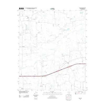
2013 Map of Dike
USGS Topo · Published 2013About this map
White Oak Creek and its many tributaries, including Lollars Branch and Briar Branch, define the low-lying drainage patterns of north-central Hopkins County. The settlement of Dike serves as a primary hub in the northwest, while the community of East Caney sits near the southern boundary. This map reveals a landscape heavily segmented by rural county roads and agricultural land use, punctuated by small private water bodies such as Patterson Lake and Wholecattle Feeders Lake B. For those researching local family histories, the locations of Connor Cemetery and Bennett Cemetery provide essential geographic context for early residents. The southern portion of the quadrangle is marked by more modern infrastructure, including the highway corridor at White Oak Junction and the small siding or community of Weaver.
Find a feature on this map
71 named features on this map. Tap any name to fly to it.
Don’t see what you’re looking for? This feature index may not catch every label — zoom into the map to look around manually.
Map Details
Editions of this 2013 Dike Map
This is the sole edition of this map. No revisions or reprints were ever made.
Other maps of this area

1953 · Texarkana
USGS Topo · 1:250,000

1956 · Texarkana
USGS Topo · 1:250,000

1962 · Sulphur Bluff
USGS Topo · 1:24,000

1963 · Mitchell Creek
USGS Topo · 1:24,000

1964 · Saltillo
USGS Topo · 1:24,000

1964 · Como
USGS Topo · 1:24,000

1964 · Purley
USGS Topo · 1:24,000

1964 · Sulphur Springs
USGS Topo · 1:24,000

1964 · Tira
USGS Topo · 1:24,000
1964 · Sulphur Springs SE
USGS Topo · 1:24,000