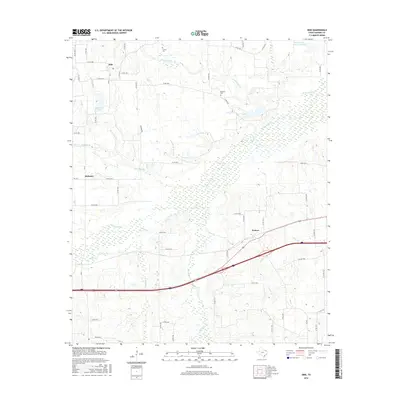
2016 Map of Dike
USGS Topo · Published 2016About this map
Dike serves as a central hub in this northeast Texas landscape, situated amongst a dense network of country roads and winding creek systems. The terrain is defined by its drainage patterns, with Crosstimber Cr and White Oak Cr carving through the prairie and woodland. For genealogists and local historians, the inclusion of Connor Cem and Bennett Cem offers precise locations for family research in this rural portion of Hopkins County. Smaller settlements like Mahoney and Weaver provide context for the distribution of residential life away from the primary town centers. The map also highlights local water features such as Patterson Lake and the uniquely named Wholecattle Feeders Lake B, illustrating the area's reliance on managed water resources for livestock and agriculture. Interstate 30 cuts across the southeastern corner, contrasting modern high-speed transit with the slower pace of the surrounding rural routes like FM 69 and Pasture Rd.
Find a feature on this map
57 named features on this map. Tap any name to fly to it.
Don’t see what you’re looking for? This feature index may not catch every label — zoom into the map to look around manually.
Map Details
Editions of this 2016 Dike Map
This is the sole edition of this map. No revisions or reprints were ever made.
Other maps of this area

1953 · Texarkana
USGS Topo · 1:250,000

1956 · Texarkana
USGS Topo · 1:250,000

1962 · Sulphur Bluff
USGS Topo · 1:24,000

1963 · Mitchell Creek
USGS Topo · 1:24,000

1964 · Saltillo
USGS Topo · 1:24,000

1964 · Como
USGS Topo · 1:24,000

1964 · Purley
USGS Topo · 1:24,000

1964 · Sulphur Springs
USGS Topo · 1:24,000

1964 · Tira
USGS Topo · 1:24,000
1964 · Sulphur Springs SE
USGS Topo · 1:24,000