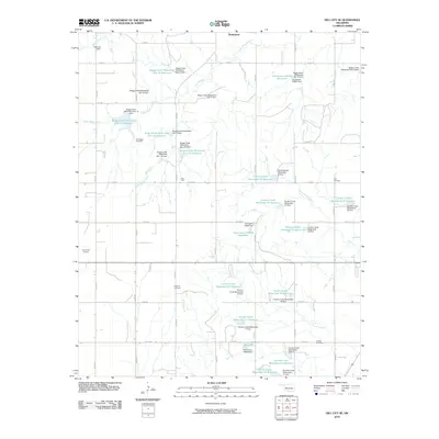
2010 Map of Dill City SE
USGS Topo · Published 2010About this map
Braithwaite and Red Bluff anchor this portion of Washita County, where a highly managed hydraulic landscape defines the rural geography. The area is characterized by an extensive network of watershed management structures, including the numerous reservoirs and dams along Boggy Creek and Cavalry Creek. This dense concentration of small-scale infrastructure, such as Boggy Creek Watershed Site 15 Reservoir and several numbered dams, illustrates the mid-century transition toward soil conservation and flood control in Oklahoma's agricultural heartland. Genealogists and local historians can trace legacy sites like Old Boggy Cemetery and Sod Cemetery, which remain as markers of early settlement patterns. Transportation is oriented around a rigid section-line road grid, with Burns Flat Junction serving as a notable point of transit between the creeks and the surrounding prairie.
Find a feature on this map
66 named features on this map. Tap any name to fly to it.
Don’t see what you’re looking for? This feature index may not catch every label — zoom into the map to look around manually.
Map Details
Editions of this 2010 Dill City SE Map
This is the sole edition of this map. No revisions or reprints were ever made.
Other maps of this area

1955 · Clinton
USGS Topo · 1:250,000

1956 · Cordell
USGS Topo · 1:62,500

1957 · Clinton
USGS Topo · 1:250,000

1957 · Dill City
USGS Topo · 1:62,500

1961 · Gotebo
USGS Topo · 1:62,500

1961 · Hobart
USGS Topo · 1:62,500

1976 · Dill City NE
USGS Topo · 1:24,000

1976 · Dill City SE
USGS Topo · 1:24,000
1983 · Bessie
USGS Topo · 1:24,000
1983 · Foss
USGS Topo · 1:24,000