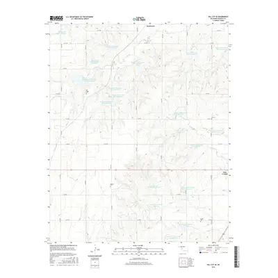
2016 Map of Dill City SE
USGS Topo · Published 2016About this map
Old Boggy Cem and Dugford Cem are central features in this rural Oklahoma landscape, which is defined by a dense network of water management sites. The terrain is dominated by the upper reaches of Boggy Cr and Cavalry Cr, along with their numerous tributaries like S Boggy Cr and N Cavalry Cr. These waterways have been extensively transformed into a series of reservoirs, including the Klemme Reservoir and more than a dozen watershed sites such as Boggy Creek Watershed Site 14 Reservoir and Cavalry Cr Watershed 22 Reservoir.
Find a feature on this map
46 named features on this map. Tap any name to fly to it.
Don’t see what you’re looking for? This feature index may not catch every label — zoom into the map to look around manually.
Map Details
Editions of this 2016 Dill City SE Map
This is the sole edition of this map. No revisions or reprints were ever made.
Other maps of this area

1955 · Clinton
USGS Topo · 1:250,000

1956 · Cordell
USGS Topo · 1:62,500

1957 · Clinton
USGS Topo · 1:250,000

1957 · Dill City
USGS Topo · 1:62,500

1961 · Gotebo
USGS Topo · 1:62,500

1961 · Hobart
USGS Topo · 1:62,500

1976 · Dill City NE
USGS Topo · 1:24,000

1976 · Dill City SE
USGS Topo · 1:24,000
1983 · Bessie
USGS Topo · 1:24,000
1983 · Foss
USGS Topo · 1:24,000