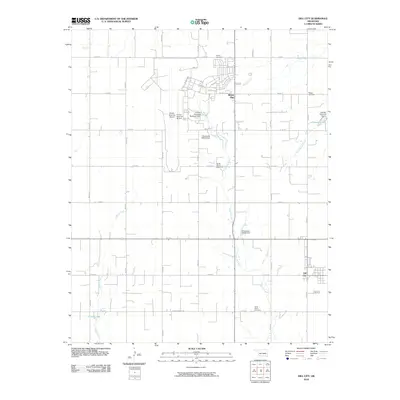
2010 Map of Dill City
USGS Topo · Published 2010About this map
Burns Flat and the expansive infrastructure of the Clinton-Sherman Airport dominate this corner of Washita County. The landscape is defined by a rigorous section-line road grid, including 2nd St and Webb St, which connects rural homesteads to the primary settlements. To the southeast, Dill City sits along the southern extent of the survey area, anchored by local transport routes like E1200 Rd. Water management is a critical feature of the terrain, evidenced by the Clinton-Sherman Reservoir Dam and several unnamed dams regulating the flow of Little Elk Creek and Boggy Creek. For genealogists, the map is particularly useful for locating smaller burial grounds such as Novis Cemetery, Boggy Cemetery, and the North Burns Cemetery, which mark the early 20th-century settlement patterns of the Oklahoma plains.
Find a feature on this map
33 named features on this map. Tap any name to fly to it.
Don’t see what you’re looking for? This feature index may not catch every label — zoom into the map to look around manually.
Map Details
Editions of this 2010 Dill City Map
This is the sole edition of this map. No revisions or reprints were ever made.
Other maps of this area

1955 · Clinton
USGS Topo · 1:250,000

1957 · Clinton
USGS Topo · 1:250,000

1957 · Dill City
USGS Topo · 1:62,500

1961 · Hobart
USGS Topo · 1:62,500

1961 · Retrop
USGS Topo · 1:62,500

1961 · Elk City
USGS Topo · 1:62,500

1976 · Dill City NE
USGS Topo · 1:24,000

1976 · Dill City SE
USGS Topo · 1:24,000
1983 · Foss
USGS Topo · 1:24,000

1983 · Dill City
USGS Topo · 1:24,000