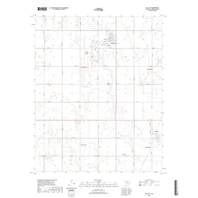
2018 Map of Dill City
USGS Topo · Published 2018About this map
Clinton-Sherman Airport dominates the central landscape of this Washita County region, marking a significant piece of Oklahoma aviation infrastructure near the town of Burns Flat. The surrounding area is defined by a grid of rural section roads, including Flying J Ranch Rd and Choctaw Rd, which connect scattered homesteads and agricultural plots. To the southeast, the grid consolidates at the town of Dill City, while the natural topography is shaped by the meandering courses of Little Elk Cr and Monument Cr.
Find a feature on this map
44 named features on this map. Tap any name to fly to it.
Don’t see what you’re looking for? This feature index may not catch every label — zoom into the map to look around manually.
Map Details
Editions of this 2018 Dill City Map
This is the sole edition of this map. No revisions or reprints were ever made.
Other maps of this area

1955 · Clinton
USGS Topo · 1:250,000

1957 · Clinton
USGS Topo · 1:250,000

1957 · Dill City
USGS Topo · 1:62,500

1961 · Hobart
USGS Topo · 1:62,500

1961 · Retrop
USGS Topo · 1:62,500

1961 · Elk City
USGS Topo · 1:62,500

1976 · Dill City NE
USGS Topo · 1:24,000

1976 · Dill City SE
USGS Topo · 1:24,000
1983 · Foss
USGS Topo · 1:24,000

1983 · Dill City
USGS Topo · 1:24,000