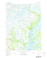
1952 Map of Dillingham A-3
USGS Topo · Published 1962About this map
The Kvichak River dominates this mid-century landscape as it winds through an intricate network of lakes, ponds, and marshy lowlands typical of the Bristol Bay region. Near the river's center course, the settlement of Levelock is visible, supported by a nearby Landing Strip and a Winter Trail that provided essential overland access during the colder months. To the south, where the Alagnak River joins the system, the small cluster at Hallersville sits along its namesake Hallersville Creek. The mapping reveals a delicate hydrosystem where Tidal Flats and numerous tributaries like Yellow Creek and Bear Creek illustrate the tidal influence and drainage patterns of the Alaskan wilderness. This survey is particularly valuable for documenting the precise location of riverside Cabins and infrastructure during a period when seasonal travel and subsistence living were the primary drivers of the local economy.
Find a feature on this map
14 named features on this map. Tap any name to fly to it.
Don’t see what you’re looking for? This feature index may not catch every label — zoom into the map to look around manually.
Map Details
Editions of this 1952 Dillingham A-3 Map
2 editions found
Other maps of this area

1951 · Dillingham
USGS Topo · 1:250,000

1952 · Naknek
USGS Topo · 1:250,000

1952 · Dillingham A-2
USGS Topo · 1:63,360

1952 · Dillingham A-4
USGS Topo · 1:63,360

1952 · Dillingham A-3
USGS Topo · 1:63,360

1952 · Naknek D-3
USGS Topo · 1:63,360

1952 · Naknek D-4
USGS Topo · 1:63,360

1954 · Dillingham
USGS Topo · 1:250,000

1954 · Dillingham B-4
USGS Topo · 1:63,360
1954 · Dillingham B-2
USGS Topo · 1:63,360