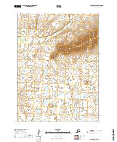
2019 Map of Dillingham D-3 NW
USGS Topo · Published 2019About this map
Harris Creek and its tributaries flow through this remote landscape in the Dillingham Census Area, defining a terrain of numerous small lakes and varying elevation. In the northern reaches of the quadrangle, Harris Cr winds through a valley between significant ridges, while further south, the drainage patterns shift as Cranberry Cr navigates a lower, wetland-rich environment. This 2019 survey documents the intricate hydrography of the region, where the water table and surface topography create a complex network of unnamed ponds and marshes across the townships of T2S R46W and T3S R45W. The landscape is characterized by its lack of infrastructure, illustrating the wild character of this part of Alaska where natural drainage and contour lines remain the primary geographic landmarks.
Find a feature on this map
6 named features on this map. Tap any name to fly to it.
Don’t see what you’re looking for? This feature index may not catch every label — zoom into the map to look around manually.
Map Details
Editions of this 2019 Dillingham D-3 NW Map
This is the sole edition of this map. No revisions or reprints were ever made.
Other maps of this area

1950 · Taylor Mountains
USGS Topo · 1:250,000

1951 · Taylor Mountains
USGS Topo · 1:250,000

1951 · Dillingham
USGS Topo · 1:250,000

1954 · Taylor Mountains
USGS Topo · 1:250,000

1954 · Dillingham
USGS Topo · 1:250,000

1954 · Dillingham D-3
USGS Topo · 1:63,360

1954 · Taylor Mountains A-4
USGS Topo · 1:63,360

1954 · Dillingham D-4
USGS Topo · 1:63,360
1954 · Taylor Mountains A-3
USGS Topo · 1:63,360
2019 · Dillingham D-4 NE
USGS Topo · 1:25,000