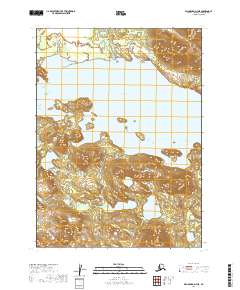
2019 Map of Dillingham D-7 NE
USGS Topo · Published 2019About this map
Tikchik Lake dominates this 2019 survey, representing the intricate freshwater systems of the Dillingham Census Area in Southwest Alaska. The transition from the Tikchik River into the massive lake basin reveals a landscape where high-relief ridges alternate with expansive glacial waters. The topography here is defined by significant elevation changes, with contours marking several prominent unnamed peaks that overlook the western and southern shores. These features are situated within the Public Land Survey System grids of t2s r53w and t3s r53w, illustrating the remote and largely undeveloped nature of this region. The map provides a detailed view of the natural hydrology and terrain before the influence of significant permanent human infrastructure, making it a critical record for understanding the original topography of this wilderness area.
Find a feature on this map
6 named features on this map. Tap any name to fly to it.
Don’t see what you’re looking for? This feature index may not catch every label — zoom into the map to look around manually.
Map Details
Editions of this 2019 Dillingham D-7 NE Map
This is the sole edition of this map. No revisions or reprints were ever made.
Other maps of this area

1950 · Taylor Mountains
USGS Topo · 1:250,000

1951 · Taylor Mountains
USGS Topo · 1:250,000

1951 · Dillingham
USGS Topo · 1:250,000

1954 · Taylor Mountains
USGS Topo · 1:250,000

1954 · Dillingham
USGS Topo · 1:250,000

1954 · Dillingham D-6
USGS Topo · 1:63,360

1954 · Dillingham D-7
USGS Topo · 1:63,360

1954 · Taylor Mountains A-6
USGS Topo · 1:63,360
1954 · Taylor Mountains A-7
USGS Topo · 1:63,360
2019 · Dillingham D-6 NW
USGS Topo · 1:25,000