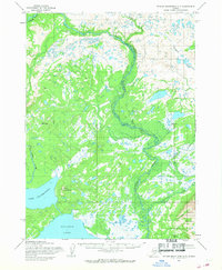
1954 Map of Taylor Mountains A-7
USGS Topo · Published 1968About this map
Tikchik River meanders through a landscape defined by expansive water bodies and tundra in this mid-1950s survey of southwestern Alaska. The map highlights the confluence of major waterways, including the Allen River and several large basins like Chaeukuktul Lake and the northern reaches of Nuyakuk Lake. Topographical prominence is found at Mount Chau fchivak and Tikchik Mountain, which stand as landmarks in an area otherwise characterized by numerous smaller ponds and marshy stretches such as those surrounding Swan Lake. This document, based on aerial photography from 1953 and 1955, records the hydrography of the region before significant modern development, showing the natural drainage patterns of Grayling Creek and Koneruk Creek as they feed into the larger river systems.
Find a feature on this map
10 named features on this map. Tap any name to fly to it.
Don’t see what you’re looking for? This feature index may not catch every label — zoom into the map to look around manually.
Map Details
Editions of this 1954 Taylor Mountains A-7 Map
3 editions found
Other maps of this area

1950 · Taylor Mountains
USGS Topo · 1:250,000

1951 · Taylor Mountains
USGS Topo · 1:250,000

1951 · Dillingham
USGS Topo · 1:250,000

1954 · Taylor Mountains
USGS Topo · 1:250,000

1954 · Dillingham
USGS Topo · 1:250,000

1954 · Dillingham D-6
USGS Topo · 1:63,360

1954 · Dillingham D-7
USGS Topo · 1:63,360

1954 · Taylor Mountains B-8
USGS Topo · 1:63,360

1954 · Taylor Mountains A-8
USGS Topo · 1:63,360

1954 · Taylor Mountains B-7
USGS Topo · 1:63,360