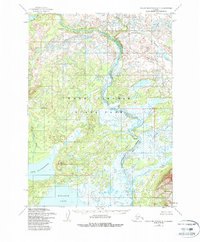
1954 Map of Taylor Mountains A-7
USGS Topo · Published 1988About this map
Wood-Tikchik State Park dominates this mid-century topographic record, showcasing a vast aquatic network of glacial lakes and connected waterways. The terrain is defined by the massive expanse of Nuyakuk Lake and Lake Chauekuktuli, separated by the prominent Mount Chauvchivak. The Tikchik River meanders through the central valley, flanked by expansive wetlands and complex drainage patterns including the Allen River and Koneruk Creek. Rising above the eastern plains, Tikchik Mountain provides a significant landmark in an area otherwise characterized by low-relief swamps and intricate shorelines. The absence of roads or established trails on this 1954 survey emphasizes the remote nature of this wilderness area prior to modern recreational development.
Find a feature on this map
8 named features on this map. Tap any name to fly to it.
Don’t see what you’re looking for? This feature index may not catch every label — zoom into the map to look around manually.
Map Details
Editions of this 1954 Taylor Mountains A-7 Map
3 editions found
Other maps of this area

1950 · Taylor Mountains
USGS Topo · 1:250,000

1951 · Taylor Mountains
USGS Topo · 1:250,000

1951 · Dillingham
USGS Topo · 1:250,000

1954 · Taylor Mountains
USGS Topo · 1:250,000

1954 · Dillingham
USGS Topo · 1:250,000

1954 · Dillingham D-6
USGS Topo · 1:63,360

1954 · Dillingham D-7
USGS Topo · 1:63,360

1954 · Taylor Mountains B-8
USGS Topo · 1:63,360

1954 · Taylor Mountains A-8
USGS Topo · 1:63,360

1954 · Taylor Mountains B-7
USGS Topo · 1:63,360