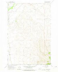
1962 Map of Dillon East
USGS Topo · Published 1975About this map
Dillon sits at the edge of the Beaverhead River valley in this early 1960s survey, showing the town as a vital regional hub where valley agriculture meets the rising terrain of the East Bench. The landscape is defined by its water management systems, including the extensive Dillon Ditch and a large canal system noted as being under construction at the time of the field check. This infrastructure highlights the era's transition toward expanded irrigation and local development. Genealogy and local history researchers will find the Mountain View Cemetery clearly marked, along with community landmarks like the Dillon Municipal Golf Course and the Dillon Airport. Further south and east, the map traces the winding course of Blacktail Deer Creek and the varied topography of Hoffman Gulch and Axes Canyon, illustrating the shift from river-bottom settlements to the high, arid benches of Beaverhead County.
Find a feature on this map
26 named features on this map. Tap any name to fly to it.
Don’t see what you’re looking for? This feature index may not catch every label — zoom into the map to look around manually.
Map Details
Editions of this 1962 Dillon East Map
4 editions found
Other maps of this area

1893 · Dillon
USGS Topo · 1:250,000

1952 · Gallagher Mountain
USGS Topo · 1:24,000

1955 · Dillon
USGS Topo · 1:250,000

1957 · Dillon
USGS Topo · 1:250,000

1958 · Dillon
USGS Topo · 1:250,000

1961 · Glen SE
USGS Topo · 1:24,000

1961 · Christensen Ranch
USGS Topo · 1:24,000

1961 · Ashbough Canyon
USGS Topo · 1:24,000

1961 · Elk Gulch
USGS Topo · 1:24,000

1962 · Dillon
USGS Topo · 1:250,000