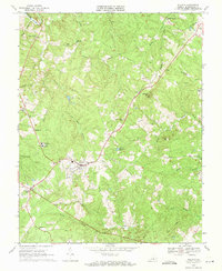
1968 Map of Dillwyn
USGS Topo · Published 1971About this map
The town of Dillwyn serves as the focal point of this late-1960s survey, situated at the junction of several critical regional roads and the Chesapeake and Ohio railroad line. The landscape is a network of small creeks and branches, including Troublesome Creek, Whispering Creek, and Rosney Creek, which supported local industry and agriculture during this era. Evidence of community life is abundant through the mapping of Woodson High Sch, Ellis Sch, and numerous country churches such as Hanes Chapel and Mourning Valley Ch.
Find a feature on this map
49 named features on this map. Tap any name to fly to it.
Don’t see what you’re looking for? This feature index may not catch every label — zoom into the map to look around manually.
Map Details
Editions of this 1968 Dillwyn Map
3 editions found
Other maps of this area

1891 · Palmyra
USGS Topo · 1:125,000

1891 · Farmville
USGS Topo · 1:125,000

1892 · Buckingham
USGS Topo · 1:125,000

1892 · Appomattox
USGS Topo · 1:125,000

1893 · Farmville
USGS Topo · 1:125,000

1895 · Palmyra
USGS Topo · 1:125,000

1897 · Palmyra
USGS Topo · 1:125,000

1947 · Roanoke
USGS Topo · 1:250,000

1950 · Dillwyn
USGS Topo · 1:62,500

1958 · Farmville
USGS Topo · 1:62,500