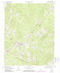
1968 Map of Dillwyn
USGS Topo · Published 1987About this map
Dillwyn stands as the primary hub of this Buckingham County landscape, where the CSX rail line curves through a terrain defined by ridges and creek valleys. The settlement pattern reveals a series of smaller rural centers such as Sprouses Corner, Alpha, and Eldridge Mill, connected by winding roads that follow the high ground between drainages like Troublesome Creek and Whispering Creek. The map documents a significant network of community anchors, from the Woodson High Sch to numerous family cemeteries and churches including Hanes Chapel Cem and Gold Mine Ch. North of the main town, Buffards Mtn and Mourning Valley provide distinct topographical landmarks, while Dillwyn Lake and several quarries reflect the local intersection of natural resources and infrastructure during the late twentieth century.
Find a feature on this map
50 named features on this map. Tap any name to fly to it.
Don’t see what you’re looking for? This feature index may not catch every label — zoom into the map to look around manually.
Map Details
Editions of this 1968 Dillwyn Map
3 editions found
Other maps of this area

1891 · Palmyra
USGS Topo · 1:125,000

1891 · Farmville
USGS Topo · 1:125,000

1892 · Buckingham
USGS Topo · 1:125,000

1892 · Appomattox
USGS Topo · 1:125,000

1893 · Farmville
USGS Topo · 1:125,000

1895 · Palmyra
USGS Topo · 1:125,000

1897 · Palmyra
USGS Topo · 1:125,000

1947 · Roanoke
USGS Topo · 1:250,000

1950 · Dillwyn
USGS Topo · 1:62,500

1958 · Farmville
USGS Topo · 1:62,500