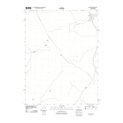
2011 Map of Dinosaur
USGS Topo · Published 2011About this map
The town of Dinosaur sits at the high northern edge of this high-desert landscape on the Colorado-Utah border. The terrain is defined by dramatic geological features including Raven Ridge, Squaw Ridge, and the Deadman Bench Divide, which separate the northern plateaus from the low expanse of Coyote Basin to the south. This area is characterized by sparse connectivity, with Snake John Reef Cutoff Rd slicing diagonally across the ridges to link the remote interior with Blue Mountain Ave. Human activity in this arid environment is evidenced by the Rich Mine, situated in the rugged territory east of the main ridge. To the southeast, the geography funnels through Mormon Gap, while the drainage of Dripping Rock Creek snakes along the eastern boundary, illustrating the vital role of water and natural passes in navigating this corner of Moffat County.
Find a feature on this map
12 named features on this map. Tap any name to fly to it.
Don’t see what you’re looking for? This feature index may not catch every label — zoom into the map to look around manually.
Map Details
Editions of this 2011 Dinosaur Map
This is the sole edition of this map. No revisions or reprints were ever made.
Other maps of this area

1885 · Ashley
USGS Topo · 1:250,000

1907 · Rangely
USGS Topo · 1:125,000

1907 · Jensen
USGS Topo · 1:125,000

1910 · Jensen
USGS Topo · 1:125,000

1910 · Rangely
USGS Topo · 1:125,000

1954 · Vernal
USGS Topo · 1:250,000

1958 · Vernal
USGS Topo · 1:250,000

1960 · Vernal
USGS Topo · 1:250,000
1962 · Mellen Hill
USGS Topo · 1:24,000
1962 · Plug Hat Rock
USGS Topo · 1:24,000