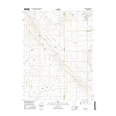
2016 Map of Dinosaur
USGS Topo · Published 2016About this map
The town of Dinosaur anchors the northeastern corner of this high-desert landscape where the borders of Utah and Colorado meet. The street names in the settlement reflect its unique proximity to nearby paleontological sites, featuring thoroughfares such as Stegosaurus Hwy and Camptosaurus Pwy. Beyond the town site, the terrain is dominated by prominent geological features like Snake John Reef and the long spine of Raven Ridge, which cuts diagonally through the central portion of the map. These ridges create natural barriers and corridors that define the local drainage patterns for Snake John Wash and Powder Springs Wash. To the south, the topography shifts into the broad expanse of Coyote Basin, separated from northern drainages by the Deadman Bench Divide. This area remains largely uninhabited, characterized by its network of canyons and gaps, including Mormon Gap and the winding course of Dripping Rock Cr.
Find a feature on this map
28 named features on this map. Tap any name to fly to it.
Don’t see what you’re looking for? This feature index may not catch every label — zoom into the map to look around manually.
Map Details
Editions of this 2016 Dinosaur Map
This is the sole edition of this map. No revisions or reprints were ever made.
Other maps of this area

1885 · Ashley
USGS Topo · 1:250,000

1907 · Rangely
USGS Topo · 1:125,000

1907 · Jensen
USGS Topo · 1:125,000

1910 · Jensen
USGS Topo · 1:125,000

1910 · Rangely
USGS Topo · 1:125,000

1954 · Vernal
USGS Topo · 1:250,000

1958 · Vernal
USGS Topo · 1:250,000

1960 · Vernal
USGS Topo · 1:250,000
1962 · Mellen Hill
USGS Topo · 1:24,000
1962 · Plug Hat Rock
USGS Topo · 1:24,000