1968 Map of Dinosaur
USGS Topo · Published 1970About this map
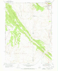
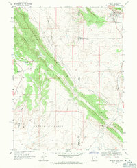
Dinosaur occupies the northeastern corner of this landscape, situated just south of the Snake John Reef along the border of Utah and Colorado. The town’s layout in the late 1960s includes a small Cem and Sewage Disposal Ponds, reflecting the local infrastructure of the era. The terrain is dominated by the prominent NW-SE trending Raven Ridge and Squaw Ridge, which divide the hydrologic landscape between Snake John Wash and Powder Springs Wash. To the south, the Coyote Basin reveals the industrial footprint of the Coyote Basin Oil Field, characterized by a network of unimproved roads and several drill holes. This high-desert environment is further defined by geologic landmarks like Deadman Bench and the narrow passage at Mormon Gap, providing a clear record of energy exploration and settlement patterns at the edge of the Uinta Basin.
Find a feature on this map
22 named features on this map. Tap any name to fly to it.
Don’t see what you’re looking for? This feature index may not catch every label — zoom into the map to look around manually.
Map Details
Editions of this 1968 Dinosaur Map
2 editions found
Other maps of this area

1885 · Ashley
USGS Topo · 1:250,000

1907 · Rangely
USGS Topo · 1:125,000

1907 · Jensen
USGS Topo · 1:125,000

1910 · Jensen
USGS Topo · 1:125,000
1910 · Rangely
USGS Topo · 1:125,000

1954 · Vernal
USGS Topo · 1:250,000

1958 · Vernal
USGS Topo · 1:250,000

1960 · Vernal
USGS Topo · 1:250,000

1962 · Mellen Hill
USGS Topo · 1:24,000
1962 · Plug Hat Rock
USGS Topo · 1:24,000