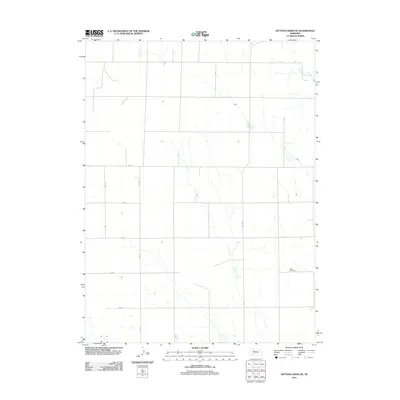
2011 Map of Dittons Creek NE
USGS Topo · Published 2011About this map
The Attica Cemetery serves as a primary historical landmark in this section of Chase County, marking a localized pocket of settlement within a landscape defined by a precise section-line road grid. The geography is characterized by the meandering path of Blackwood Creek in the northeast and intermittent drainage patterns that break the regularity of the agricultural plats. Longstanding transit routes like Old Hwy 17 and a network of numeric roads, including 750 Rd and 348 Ave, underscore the rural infrastructure maintained through the early 21st century. This survey documents the intersection of natural watercourses and the human-imposed geometry of the Nebraska plains, reflecting the enduring township-and-range system in a sparsely populated agricultural region.
Find a feature on this map
10 named features on this map. Tap any name to fly to it.
Don’t see what you’re looking for? This feature index may not catch every label — zoom into the map to look around manually.
Map Details
Editions of this 2011 Dittons Creek NE Map
This is the sole edition of this map. No revisions or reprints were ever made.
Other maps of this area

1954 · McCook
USGS Topo · 1:250,000

1957 · McCook
USGS Topo · 1:250,000

1958 · McCook
USGS Topo · 1:250,000
1973 · Grainton
USGS Topo · 1:24,000

1973 · Dittons Creek NE
USGS Topo · 1:24,000

1973 · Dittons Creek NW
USGS Topo · 1:24,000
1973 · Elsie
USGS Topo · 1:24,000
1973 · Wallace
USGS Topo · 1:24,000

1973 · Hayes Center NW
USGS Topo · 1:24,000

1974 · Dittons Creek SE
USGS Topo · 1:24,000