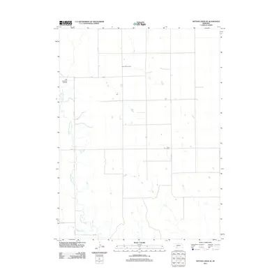
2011 Map of Dittons Creek SE
USGS Topo · Published 2011About this map
Stinking Water Creek and its southern tributary Spring Creek define the drainage patterns of this Chase County landscape. The terrain is notably marked by Cliff Dwellers Canyon in the northwest, a distinctive landform among the section lines of the Nebraska high plains. Human presence is anchored by small rural burial grounds, including Saint John Cemetery and Elmer Cemetery, which serve as vital markers for genealogical research in this sparsely populated agricultural region. The grid system of county roads, such as 348 Ave and 740 Rd, underscores the modern land division, while the label for Old Hwy 17 preserves the memory of earlier transportation corridors through the plains.
Find a feature on this map
10 named features on this map. Tap any name to fly to it.
Don’t see what you’re looking for? This feature index may not catch every label — zoom into the map to look around manually.
Map Details
Editions of this 2011 Dittons Creek SE Map
This is the sole edition of this map. No revisions or reprints were ever made.
Other maps of this area

1954 · McCook
USGS Topo · 1:250,000

1957 · McCook
USGS Topo · 1:250,000

1958 · McCook
USGS Topo · 1:250,000

1973 · Dittons Creek NE
USGS Topo · 1:24,000

1973 · Dittons Creek NW
USGS Topo · 1:24,000

1973 · Hayes Center NW
USGS Topo · 1:24,000

1974 · Hamlet
USGS Topo · 1:24,000

1974 · Dittons Creek SE
USGS Topo · 1:24,000
1974 · Wauneta West
USGS Topo · 1:24,000
1974 · Dittons Creek
USGS Topo · 1:24,000