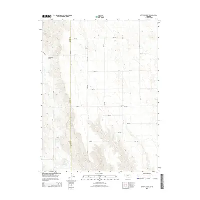
2014 Map of Dittons Creek SE
USGS Topo · Published 2014About this map
Stinking Water Cr meanders through the western reaches of this landscape, joined by the headwaters of Spring Cr near the southern border. The terrain is defined by the sharp drop-offs of Cliff Dwellers Canyon and a network of section roads that crisscross the high plains. This 2014 survey documents the rural character of the borderlands between Chase County and Hayes County, Nebraska. Small communal landmarks serve as important historical anchors in this sparsely populated region, including Saint John Cem in the north and Elmer Cem further south. The map provides a precise look at the modern rural infrastructure, showing the alignment of local routes like Road 744 and Avenue 350 as they navigate the subtle shifts in elevation across the Nebraska panhandle.
Find a feature on this map
25 named features on this map. Tap any name to fly to it.
Don’t see what you’re looking for? This feature index may not catch every label — zoom into the map to look around manually.
Map Details
Editions of this 2014 Dittons Creek SE Map
This is the sole edition of this map. No revisions or reprints were ever made.
Other maps of this area

1954 · McCook
USGS Topo · 1:250,000

1957 · McCook
USGS Topo · 1:250,000

1958 · McCook
USGS Topo · 1:250,000

1973 · Dittons Creek NE
USGS Topo · 1:24,000

1973 · Dittons Creek NW
USGS Topo · 1:24,000

1973 · Hayes Center NW
USGS Topo · 1:24,000

1974 · Hamlet
USGS Topo · 1:24,000

1974 · Dittons Creek SE
USGS Topo · 1:24,000
1974 · Wauneta West
USGS Topo · 1:24,000
1974 · Dittons Creek
USGS Topo · 1:24,000