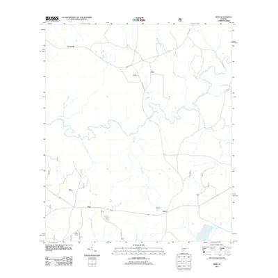
2011 Map of Dixie
USGS Topo · Published 2011About this map
The winding Conecuh River defines the central topography of this South Alabama region, where the small communities of Georgiaville, Dixie, and Rome are connected by a network of rural roads. Genealogists will find several notable family landmarks, including Smith Cemetery, Feagin Cemetery, and Mason Cemetery, which are scattered throughout the wooded terrain. The landscape is heavily influenced by a complex watershed, with numerous tributaries such as Mobley Creek, Blue Creek, and Bear Head Creek feeding into the main river channel. Near the settlement of Dixie, the Dixie Lookout Tower stands as a significant landmark for fire surveillance in this timber-rich area. The eastern portion of the map is dominated by the flow of Eden Creek and the localized Rome Pond, illustrating a quiet, rural interior characterized by small-scale settlements and natural drainage patterns.
Find a feature on this map
19 named features on this map. Tap any name to fly to it.
Don’t see what you’re looking for? This feature index may not catch every label — zoom into the map to look around manually.
Map Details
Editions of this 2011 Dixie Map
This is the sole edition of this map. No revisions or reprints were ever made.
Other maps of this area

1953 · Andalusia
USGS Topo · 1:250,000

1957 · Andalusia
USGS Topo · 1:250,000

1971 · Dixie
USGS Topo · 1:24,000

1971 · Bradley
USGS Topo · 1:24,000

1971 · Carolina
USGS Topo · 1:24,000

1971 · Wing
USGS Topo · 1:24,000

1971 · River Falls
USGS Topo · 1:24,000

1971 · Loango
USGS Topo · 1:24,000

1982 · Damascus
USGS Topo · 1:24,000
1982 · Brooklyn
USGS Topo · 1:24,000