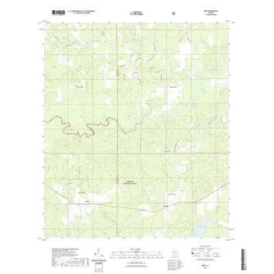
2021 Map of Dixie
USGS Topo · Published 2021About this map
Conecuh River meanders across this South Alabama landscape, defining the transition between the rolling hills and the expansive timberlands of the Conecuh National Forest. The map centers on the rural communities of Dixie and Rome, areas where the geography is heavily influenced by a network of waterways including Mobley Cr, Douglas Mill Cr, and Bear Head Cr. These drainage patterns historically supported local milling and agricultural operations, reflected in road names like Douglas Mill Rd.
Find a feature on this map
44 named features on this map. Tap any name to fly to it.
Don’t see what you’re looking for? This feature index may not catch every label — zoom into the map to look around manually.
Map Details
Editions of this 2021 Dixie Map
This is the sole edition of this map. No revisions or reprints were ever made.
Other maps of this area

1953 · Andalusia
USGS Topo · 1:250,000

1957 · Andalusia
USGS Topo · 1:250,000

1971 · Dixie
USGS Topo · 1:24,000

1971 · Bradley
USGS Topo · 1:24,000

1971 · Carolina
USGS Topo · 1:24,000

1971 · Wing
USGS Topo · 1:24,000

1971 · River Falls
USGS Topo · 1:24,000

1971 · Loango
USGS Topo · 1:24,000

1982 · Damascus
USGS Topo · 1:24,000
1982 · Brooklyn
USGS Topo · 1:24,000