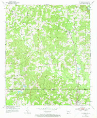
1952 Map of Doddridge
USGS Topo · Published 1973About this map
The Arkansas-Louisiana state line divides this 1952 topographic study, where the rural landscapes of Miller County and Caddo Parish meet. The Texas and Pacific railroad serves as a primary north-south corridor, connecting small settlements like Doddridge and Ida through a terrain defined by the winding course of Kelly Bayou and its many tributaries, including East Fork and West Fork.
Find a feature on this map
33 named features on this map. Tap any name to fly to it.
Don’t see what you’re looking for? This feature index may not catch every label — zoom into the map to look around manually.
Map Details
Editions of this 1952 Doddridge Map
5 editions found
Other maps of this area

1907 · Atlanta
USGS Topo · 1:62,500

1910 · Atlanta
USGS Topo · 1:62,500

1932 · Hosston NW
USGS Topo · 1:31,680

1932 · Hosston NE
USGS Topo · 1:31,680

1944 · Kildare
USGS Topo · 1:62,500

1948 · Kildare
USGS Topo · 1:62,500

1948 · Vivian
USGS Topo · 1:62,500

1952 · Doddridge SE
USGS Topo · 1:24,000

1952 · Doddridge NW
USGS Topo · 1:24,000

1952 · Doddridge
USGS Topo · 1:24,000