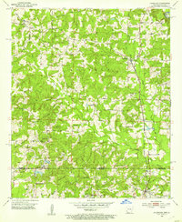
1952 Map of Doddridge
USGS Topo · Published 1953About this map
Kelly Bayou and its many tributaries, including the East Fork Kelly Bayou and West Fork Kelly Bayou, define the landscape of the Arkansas-Louisiana borderlands in this early 1950s survey. The area exhibits a rural settlement pattern centered on the town of Doddridge and several smaller communities such as Brightstar and Kiblah. Industrial activity is evident near the southern border at Ida, where an Oil Refinery and Oil Tanks sit adjacent to the Texas and Pacific railroad tracks. This rail line serves as a primary transit corridor through the valley. Local life is anchored by numerous country churches and burial grounds, including Mt Pleasant Ch, Evergreen Ch, and the Sulphur Fork Cem. The terrain is marked by the Sulphur hills, dissected by numerous small branches like Day Branch and Pill Branch, reflecting the region's complex drainage system before modern development.
Find a feature on this map
31 named features on this map. Tap any name to fly to it.
Don’t see what you’re looking for? This feature index may not catch every label — zoom into the map to look around manually.
Map Details
Editions of this 1952 Doddridge Map
5 editions found
Other maps of this area

1907 · Atlanta
USGS Topo · 1:62,500

1910 · Atlanta
USGS Topo · 1:62,500

1932 · Hosston NW
USGS Topo · 1:31,680

1932 · Hosston NE
USGS Topo · 1:31,680

1944 · Kildare
USGS Topo · 1:62,500

1948 · Kildare
USGS Topo · 1:62,500

1948 · Vivian
USGS Topo · 1:62,500

1952 · Doddridge SE
USGS Topo · 1:24,000

1952 · Doddridge NW
USGS Topo · 1:24,000

1952 · Doddridge
USGS Topo · 1:24,000