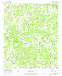
1952 Map of Doddridge
USGS Topo · Published 1976About this map
Sulphur River lowlands and the rolling hills of the Arkansas-Louisiana borderlands define this mid-century survey. The landscape is characterized by a network of drainage creeks and bayous, including Kelly Bayou and the East Fork, which supported scattered rural communities during the early 1950s. The presence of an Oil Refinery near Capps City and a Flowing Well further south indicate the region's industrial ties to petroleum extraction, a significant shift from purely agrarian roots.
Find a feature on this map
30 named features on this map. Tap any name to fly to it.
Don’t see what you’re looking for? This feature index may not catch every label — zoom into the map to look around manually.
Map Details
Editions of this 1952 Doddridge Map
5 editions found
Other maps of this area

1907 · Atlanta
USGS Topo · 1:62,500

1910 · Atlanta
USGS Topo · 1:62,500

1932 · Hosston NW
USGS Topo · 1:31,680

1932 · Hosston NE
USGS Topo · 1:31,680

1944 · Kildare
USGS Topo · 1:62,500

1948 · Kildare
USGS Topo · 1:62,500

1948 · Vivian
USGS Topo · 1:62,500

1952 · Doddridge SE
USGS Topo · 1:24,000

1952 · Doddridge NW
USGS Topo · 1:24,000

1952 · Doddridge
USGS Topo · 1:24,000