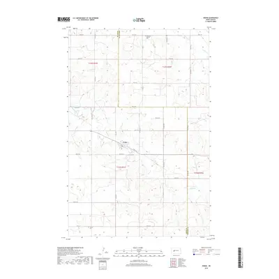
2018 Map of Dodge
USGS Topo · Published 2018About this map
Dodge serves as the central hub of this Great Plains landscape, situated along the county line where Dunn Co Mercer Co meet. The geography is defined by a dendritic network of drainages, including Goodman Cr, Spring Cr, and Cottonwood Cr, which carve through the high prairie. For those tracing family histories or early rural congregations, the presence of the Saint Pauls Lutheran Cem in the north and Loring Cem in the southwest provides concrete points of reference for former residents and early settlers. The area's infrastructure is dominated by a precise section-line road grid, featuring routes such as Co Rd 1 and numerous numbered roads like 80th Ave SW, illustrating the enduring influence of the Public Land Survey System on North Dakota's rural development.
Find a feature on this map
30 named features on this map. Tap any name to fly to it.
Don’t see what you’re looking for? This feature index may not catch every label — zoom into the map to look around manually.
Map Details
Editions of this 2018 Dodge Map
This is the sole edition of this map. No revisions or reprints were ever made.
Other maps of this area

1953 · Watford City
USGS Topo · 1:250,000

1957 · Watford City
USGS Topo · 1:250,000

1967 · Watford City
USGS Topo · 1:250,000

1970 · Halliday NE
USGS Topo · 1:24,000
1970 · Golden Valley NE
USGS Topo · 1:24,000

1970 · Golden Valley NW
USGS Topo · 1:24,000

1973 · Schaffner Creek NE
USGS Topo · 1:24,000

1973 · Schaffner Creek
USGS Topo · 1:24,000

1973 · Halliday
USGS Topo · 1:24,000

1973 · Dodge
USGS Topo · 1:24,000