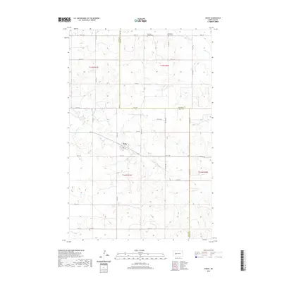
2020 Map of Dodge
USGS Topo · Published 2020About this map
Dodge sits near the center of this rural landscape, positioned at a significant intersection of local roads and watercourses. The town's grid is surrounded by the drainage patterns of Spring Cr and Cottonwood Cr, which carve through the undulating topography of Dunn and Mercer counties. The mapping reflects a deeply rooted community structure, evidenced by the clustered placement of sacred sites including Saint Pauls Lutheran Cem and the Seventh Day Adventist Cem to the north, along with Loring Cem to the south. These landmarks, along with a systematic grid of section roads like 8th St SW and 45th Ave SW, illustrate the organized land division typical of this North Dakota prairie region. To the northeast, the waters of Goodman Cr further define the local hydrology, supporting the agricultural lifeblood of the townships.
Find a feature on this map
25 named features on this map. Tap any name to fly to it.
Don’t see what you’re looking for? This feature index may not catch every label — zoom into the map to look around manually.
Map Details
Editions of this 2020 Dodge Map
This is the sole edition of this map. No revisions or reprints were ever made.
Other maps of this area

1953 · Watford City
USGS Topo · 1:250,000

1957 · Watford City
USGS Topo · 1:250,000

1967 · Watford City
USGS Topo · 1:250,000

1970 · Halliday NE
USGS Topo · 1:24,000
1970 · Golden Valley NE
USGS Topo · 1:24,000

1970 · Golden Valley NW
USGS Topo · 1:24,000

1973 · Schaffner Creek NE
USGS Topo · 1:24,000

1973 · Schaffner Creek
USGS Topo · 1:24,000

1973 · Halliday
USGS Topo · 1:24,000

1973 · Dodge
USGS Topo · 1:24,000