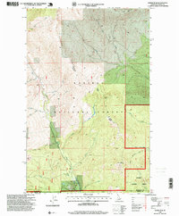
1996 Map of Dodge Peak
USGS Topo · Published 1999About this map
Apache Ridge and Ruby Ridge dominate the landscape in this high-altitude section of the Kaniksu National Forest, where the complex drainage systems of the Idaho panhandle converge. The map documents the intricate network of waterways including Ruby Creek, Fall Creek, and the south-flowing Pack River, which cuts through the western portion of the quadrangle. The steep topography is anchored by notable summits like Dodge Peak and White Mountain, showing a terrain defined by vertical relief rather than human settlement.
Find a feature on this map
28 named features on this map. Tap any name to fly to it.
Don’t see what you’re looking for? This feature index may not catch every label — zoom into the map to look around manually.
Map Details
Editions of this 1996 Dodge Peak Map
This is the sole edition of this map. No revisions or reprints were ever made.
Other maps of this area

1901 · Sandpoint
USGS Topo · 1:125,000

1911 · Priest Lake
USGS Topo · 1:250,000

1911 · Sandpoint
USGS Topo · 1:125,000

1913 · Priest Lake
USGS Topo · 1:250,000

1951 · Elmira
USGS Topo · 1:62,500

1958 · Sandpoint
USGS Topo · 1:250,000

1963 · Sandpoint
USGS Topo · 1:250,000

1965 · Moravia
USGS Topo · 1:24,000

1965 · Naples
USGS Topo · 1:24,000

1967 · The Wigwams
USGS Topo · 1:24,000