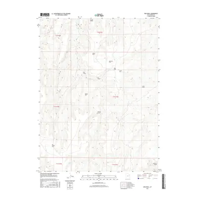
2017 Map of Dog Knoll
USGS Topo · Published 2017About this map
Tabyago Spring provides a rare water source in this high-elevation landscape of Uintah County, where the terrain is defined by a series of deep drainage systems and prominent plateaus. The topography is marked by significant features such as Tabyago Canyon and Tabyago Basin, which dominate the western half of the map. Elevated landforms like Benion Bench and the eponymous Dog Knoll rise above the surrounding draws, including Green Draw and Dog Knoll Draw. This 2017 survey reflects the remote character of the region, where numerous named canyons like Chimney Canyon, Cat Canyon, and Horsecorn Canyon intersect. The landscape transitions into broader stretches toward the south at Big Canyon Flat, while Cedar Knolls provides a distinct landmark in the east, illustrating the complex erosional patterns of the Utah backcountry.
Find a feature on this map
19 named features on this map. Tap any name to fly to it.
Don’t see what you’re looking for? This feature index may not catch every label — zoom into the map to look around manually.
Map Details
Editions of this 2017 Dog Knoll Map
This is the sole edition of this map. No revisions or reprints were ever made.
Other maps of this area

1885 · East Tavaputs
USGS Topo · 1:250,000

1953 · Nutters Hole
USGS Topo · 1:62,500

1953 · Firewater Canyon
USGS Topo · 1:62,500

1956 · Grand Junction
USGS Topo · 1:250,000

1959 · Grand Junction
USGS Topo · 1:250,000

1960 · Grand Junction
USGS Topo · 1:250,000

1962 · Grand Junction
USGS Topo · 1:250,000

1964 · Grand Junction
USGS Topo · 1:250,000

1965 · Grand Junction
USGS Topo · 1:250,000
1966 · Flat Rock Mesa
USGS Topo · 1:24,000