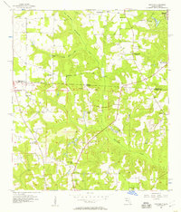
1956 Map of Dogtown
USGS Topo · Published 1957About this map
Willacoochee Creek and its tributaries, Betts Mill Creek and Fain Mill Creek, carve through the rolling hills along the Georgia Florida state line during the mid-1950s. This borderland landscape is defined by its rural community centers, featuring an extensive network of country churches such as Campbell Chapel, St Elizabeth Ch, and Mt Olive Ch. The historic Watson Line marks the political boundary between Decatur County and Gadsden County, where the transition from agriculture to industry is evident. While Oak Grove Sch (Abandoned) indicates shifting social patterns, the presence of a Strip Mine and the Attapulgus (Station) along the rail line near Crescent Lake reveals the area's economic focus. Numerous family-named burial grounds like Pottevint Cem and Taylor Cem provide essential data for those tracing local lineages in the Dogtown vicinity.
Find a feature on this map
32 named features on this map. Tap any name to fly to it.
Don’t see what you’re looking for? This feature index may not catch every label — zoom into the map to look around manually.
Map Details
Editions of this 1956 Dogtown Map
2 editions found
Other maps of this area

1954 · Tallahassee
USGS Topo · 1:250,000

1955 · Bainbridge
USGS Topo · 1:62,500

1955 · Whigham
USGS Topo · 1:62,500

1955 · Mt Pleasant
USGS Topo · 1:24,000

1956 · Havana North
USGS Topo · 1:24,000

1956 · Dogtown
USGS Topo · 1:24,000

1959 · Tallahassee
USGS Topo · 1:250,000

1959 · Gretna
USGS Topo · 1:24,000

1959 · Quincy
USGS Topo · 1:24,000

1960 · Tallahassee
USGS Topo · 1:250,000