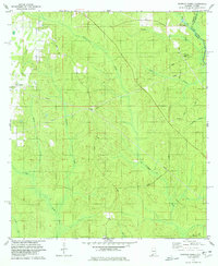
1978 Map of Dogwood Creek
USGS Topo · Published 1978About this map
Pine Grove and the surrounding woodlands of eastern Baldwin County define this 1970s landscape along the Alabama-Florida border. The area is heavily intersected by a network of energy infrastructure, with several Pipelines and a Pumping Sta cutting through the terrain. The hydrological system is complex, dominated by the Styx River in the southwest and the winding Perdido River which forms the state boundary in the northeast.
Find a feature on this map
23 named features on this map. Tap any name to fly to it.
Don’t see what you’re looking for? This feature index may not catch every label — zoom into the map to look around manually.
Map Details
Editions of this 1978 Dogwood Creek Map
4 editions found
Other maps of this area

1920 · Robertsdale
USGS Topo · 1:62,500

1921 · Fairhope
USGS Topo · 1:62,500

1941 · Bay Minette
USGS Topo · 1:62,500

1941 · Robertsdale
USGS Topo · 1:62,500

1941 · Fairhope
USGS Topo · 1:62,500

1942 · Dyas
USGS Topo · 1:62,500

1943 · Robertsdale
USGS Topo · 1:62,500

1943 · Bay Minette
USGS Topo · 1:62,500
1943 · Fairhope
USGS Topo · 1:62,500
1944 · Stapleton
USGS Topo · 1:31,680