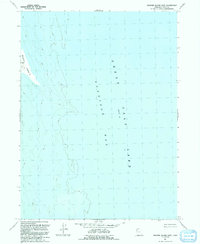
1991 Map of Dolphin Island East
USGS Topo · Published 1991About this map
Gunnison Bay dominates this late-twentieth-century study, showcasing the fluctuating shoreline and remote landscape of the northwestern Great Salt Lake. The terrain is defined by the isolated Dolphin Island on the western edge of the quadrangle, where topographic contours reveal the subtle elevation changes of this desert island. This 1991 revision, based on aerial photography from the 1960s and 1980s, focuses on the hydrologic and geological characteristics of the region, noting a base water Elevation 4200. The absence of roads or human settlements emphasizes the harsh, saline environment of northern Utah, making it a critical reference for understanding the natural history and shifting water levels of the basin.
Find a feature on this map
4 named features on this map. Tap any name to fly to it.
Don’t see what you’re looking for? This feature index may not catch every label — zoom into the map to look around manually.
Map Details
Editions of this 1991 Dolphin Island East Map
This is the sole edition of this map. No revisions or reprints were ever made.
Other maps of this area

1954 · Brigham City
USGS Topo · 1:250,000

1958 · Brigham City
USGS Topo · 1:250,000

1962 · Brigham City
USGS Topo · 1:250,000

1968 · Coyote Point
USGS Topo · 1:24,000

1969 · Spring Bay SW
USGS Topo · 1:24,000

1969 · Dolphin Island West
USGS Topo · 1:24,000

1969 · Gunnison Island SW
USGS Topo · 1:24,000

1969 · Gunnison Island
USGS Topo · 1:24,000
1969 · Gunnison Island NE
USGS Topo · 1:24,000
1969 · Dolphin Island East
USGS Topo · 1:24,000