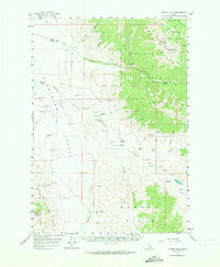
1956 Map of Donkey Hills
USGS Topo · Published 1974About this map
The Pahsimeroi Valley serves as a wide high-altitude corridor between the high peaks of the Lemhi Range and the Donkey Hills in this mid-century survey of Idaho's interior. Human activity is centered on the floor of the valley and along the Pahsimeroi River, where remote settlements like Goldburg and its namesake Goldburg Sch supported a ranching economy. Family-named holdings such as Lone Pine Ranch, Swauger Ranch, and Summit Ranch indicate the scattered nature of land use in this period. Higher elevations are dominated by the Salmon National Forest and Challis National Forest, rising to prominent points like Big Creek Peak and Flatiron Mtn. A network of water sources, including Goldburg Creek and Summit Res, highlights the critical importance of water management in this arid high-mountain environment.
Find a feature on this map
70 named features on this map. Tap any name to fly to it.
Don’t see what you’re looking for? This feature index may not catch every label — zoom into the map to look around manually.
Map Details
Editions of this 1956 Donkey Hills Map
2 editions found
Other maps of this area

1935 · Borah Peak
USGS Topo · 1:125,000

1938 · Borah Peak
USGS Topo · 1:125,000

1955 · Dubois
USGS Topo · 1:250,000

1956 · Leadore
USGS Topo · 1:62,500

1956 · Patterson
USGS Topo · 1:62,500

1956 · Donkey Hills
USGS Topo · 1:62,500

1956 · Doublespring
USGS Topo · 1:62,500

1956 · May
USGS Topo · 1:62,500

1957 · Gilmore
USGS Topo · 1:62,500

1957 · Hawley Mountain
USGS Topo · 1:62,500